USGS “Sentinel Scientists” Perform Vital but Unseen Role in Bay Restoration
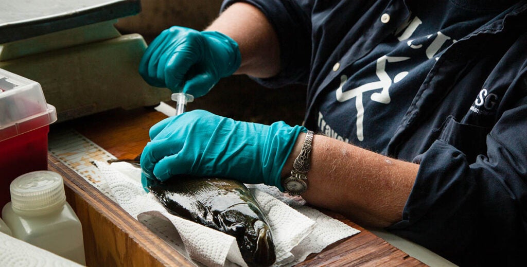
Vicki Blazer wasn’t looking for intersex fish when she started analyzing die-offs of smallmouth bass in the upper Potomac River in 2003.
But that’s where the science took Blazer, a research fishery biologist. She and her team from the U.S. Geological Survey (USGS) and the West Virginia Division of Natural Resources examined dead and disfigured fish from the Potomac’s South Branch. They found male fish with immature eggs in their testes.
Intersex fish, which have both male and female traits, could indicate that chemical pollution is disrupting their hormonal systems.
“It was a really interesting finding that kind of took off with a life of its own,” Blazer said. “Nobody else knew it was occurring. We were the first ones in this area—in the Chesapeake—to find it.”
USGS colleagues had discovered the phenomenon in major river systems like the Mississippi and the Colorado, Blazer said. But she had not expected to find them in the upper Potomac River.
Blazer went on to discover intersex smallmouth bass investigating major fish kills in Virginia’s Shenandoah River and in Maryland’s Monocacy River. USGS scientists were also the first to identify them in the Lower Susquehanna River.
A bigger follow-up study collected data at four agricultural sites over several years, tracking levels of more than 300 chemicals in the water and the health of fish swimming in it. It offers important insights to identify the risks these chemicals pose to wildlife and people and devise ways to reduce them, Blazer said.
 Will Parson/Chesapeake Bay Program
This type of work—breaking new ground, researching emerging issues, and providing unbiased science to help the restoration partners make informed decisions—is the vital but often unseen role that USGS plays in the Chesapeake Bay cleanup.
EPA leads the partnership of multiple federal agencies, seven Bay jurisdictions, and numerous local governments, community groups, and academic institutions restoring the Bay and its rivers and streams. But USGS, an Interior Department agency, supplies much of the scientific knowledge that drives it.
Roughly 100 USGS scientists are out in the field conducting long-term monitoring and research across the Bay’s 64,000-square mile watershed. That information can fill gaps in state research programs, which often lack the facilities and resources USGS has, Blazer said.
It has been instrumental in unraveling some of the biggest mysteries in Bay restoration, including the link between the pesticide DDT, thinning eggshells, and the near collapse of bald eagle, osprey, and peregrine falcon numbers in the 1960s.
USGS’s science is just as critical now, as the federal-state restoration partnership updates the Chesapeake Bay Agreement to confront the challenges of the 21st century. USGS science will be indispensable for determining which conservation strategies to pursue, whether those strategies are working, and what changes are needed if they aren’t.
“They’re the sentinel scientists in terms of looking at things nobody else is looking at and trying to understand why and then getting more information,” said Harry Campbell, Pennsylvania director of science policy and advocacy at the Chesapeake Bay Foundation and a USGS alum.
A Treasure Trove of Data
The backbone of USGS science is monitoring. USGS is the only agency in the partnership that has been tracking water quality, water levels, and land use in the region continuously in a uniform manner for decades.
Without this data, it would be “impossible” to know if the health of the ecosystem is improving, said former USGS Chesapeake Bay Coordinator Scott Phillips.
USGS leads the analysis of the Chesapeake Bay Nontidal Network of 123 monitoring stations that measure pollution in the water and chart trends in how pollution levels are is changing.
This information, which also draws on data collected by the six Bay states and the Susquehanna River Basin Commission, provides an irreplaceable annual “report card” on the states’ progress meeting their targets for reducing nitrogen, phosphorus, and sediments loads.
The agency also operates more than 400 streamflow gages in the watershed that measure the amount of water flowing in a stream. Many also monitor water temperature and water clarity.
On land, USGS is the technical lead in its partnership with the nonprofit Chesapeake Conservancy and the University of Vermont, gathering high-resolution information on land use and land cover in the region. The large data sets USGS develops enable the agency to paint the big picture of how the landscape is changing and how much land has been preserved.
Decision makers use the data to determine precisely where to target efforts to reduce pollution, like planting tree buffers, where to rebuild fish and wildlife habitat, as well as which lands to preserve and where to provide public access to communities.
“We do the research all the way from what happens on the land, to how it affects the water, to how it affects the fish, the birds, and people,” Phillips said. “We provide the information you need to attack the problems and then we can say whether your solution was successful.”
“Nobody else has the breadth of information to make those connections as USGS.”
In addition to underpinning the Chesapeake Bay restoration effort, the publicly available data is a treasure trove of information for many users.
State and local governments rely on it to delineate floodplains and determine where their communities can accommodate growth. Outdoor enthusiasts use it to check whether conditions are right for boating or fishing.
Numerous federal agencies rely on it as well, including the National Weather Service, which uses USGS streamflow data to help predict flood levels and potential hurricane damage in tidal waters.
Unbiased Research that Matters
All this data is collected with the intent to inform, not dictate, solutions.
“We are an unbiased science agency,” said current USGS Chesapeake Bay Coordinator Ken Hyer. “Our science is policy neutral.”
But that doesn’t prevent it from having a real-world impact.
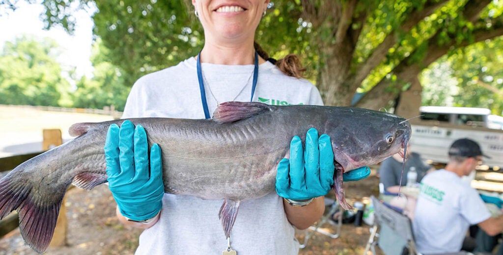
These days, Blazer is using her team’s smallmouth bass tissue samples to investigate an emerging concern in the Chesapeake Bay watershed: PFAS.
PFAS (per- and polyfluoroalkyl substances) compounds, are used in a wide variety of products, including nonstick cookware and water-repellant fabrics. They are called “forever chemicals” because they do not break down easily. As a result, they build up in the environment and in living organisms. PFAS have been linked to health problems including cancer, thyroid disease, and reduced fertility.
Blazer is looking into how PFAS accumulate in the popular game fish and whether it makes them unsafe to eat or more susceptible to disease.
 USGS Eastern Ecological Science Center
USGS Research Fish Biologist Heather Walsh, who works with Blazer researching PFAS in smallmouth bass, also studies PFAS in blue catfish.
The voracious invasive species poses an existential threat to important native Bay species like striped bass and blue crabs. The state of Maryland actively promotes their consumption as part of its campaign to reduce their numbers in its Bay tributaries.
Walsh and her team are partnering with the Maryland Department of Natural Resources to determine if PFAS levels in blue catfish make them unsafe for people to eat or for use in animal feed or fertilizer.
The state tests for PFAS, as well as mercury and pesticides, for its fish consumption advisories. But Walsh tests for contaminants the state does not track, like microplastics and the heavy metals silver, arsenic, cadmium, copper, iron, nickel, lead, and zinc. She also assesses the health of the fish.
No one else in the watershed is doing this kind of research, which will allow scientists to better relate biological changes they observe in the fish to contaminant levels they detect in the water, Walsh said.
“I hope that this research raises [people’s] awareness about fish consumption advisories, how much fish they’re consuming, where they’re catching it from, and the types of fish they’re consuming,” she said.
From troubling discoveries like intersex fish to groundbreaking research that helps guide restoration work, investments in USGS science illuminate hidden threats and pay data-driven dividends for the Bay watershed.
Related Stories
-
 Blog Story
How Has the Government Shutdown Threatened Chesapeake Bay Restoration?
Farmers working on conservation projects get hit hard
-
 Blog Story
Two Childhoods, One Bay
From flaming rivers to cleaner air, explore how 55 years of environmental action—and inaction—shape the world our children inherit.
