Land Use
The Chesapeake Bay's land-to-water ratio is 15:1—larger than any other coastal estuary in the world. When the land suffers from pollution and poor management, the Bay's water quality also worsens.
A profound relationship exists between the water of the Chesapeake Bay and the 64,000 square miles of land comprising its watershed. Approximately 100,000 rivers and streams directly connect farms, forests, and developed communities in six states and the District of Columbia with the Chesapeake.
Vast forests and wetlands once absorbed and filtered rainwater as it ran across the land to the Bay. But by the 20th century millions of acres of forest and wetlands were cleared to make way for farms and cities, removing the land’s natural filters.
Unfortunately, much of the growth that continues across the Bay watershed is sprawl. Smart, sustainable land use is an essential part of the Bay’s recovery.
How has land use changed around the Chesapeake Bay?
The Bay watershed has undergone a dramatic shift from a landscape dominated by forests and wetlands to one where sprawling development is all too common.
Before European settlers began to arrive some 400 years ago, these lands were largely forested with scattered American Indian settlements. Vast forests and wetlands absorbed and filtered rainwater as it ran across the land to the Bay.
As the population of the region grew, so did the Bay’s pollution problems. More people meant more pollution pouring into waterways from sewage, traffic, farms, and runoff. Today, there are 18 million residents in the watershed, and the number is expected to grow to 19.4 million by 2025.
What was subtracted from the watershed during historic development was as significant to the Bay’s problems as what was added. By the late 1800s, 40 to 50 percent of the watershed’s forest had been cleared of trees, according to the Chesapeake Bay Program. Between 1982 and 1997, the Bay watershed lost more than 750,000 acres of forestland to development, about 100 acres per day. Wetlands were equally decimated.
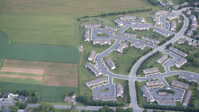
Much of the growth that continues across the Bay watershed is sprawl: insufficiently managed, scattered, spread-out development. Pockets of subdivisions and strip-malls hop-scotch into previously undeveloped forests, meadows, and farmland. Because the development is far from existing communities, the public pays for new road construction and maintenance, as well as fire, police, and other services to support this growth. Sprawl also destroys nature’s filters and increases polluted runoff.
How does sprawl threaten the Chesapeake Bay?
Sprawl converts large swaths of well-managed farms and forests—natural filters—into unconnected, spread-out, low-density residential subdivisions and commercial areas. These developments, often far from cities and town centers, make it increasingly difficult to reduce pollution.
By its very nature, sprawl increases the reliance on cars as the only means of transportation. The increase in commuting distances and traffic congestion result in more air pollution, which leads to more toxics in our waters.
The widespread proliferation of impervious surfaces such as new roads (necessary to link far-flung development), rooftops, and large parking lots (required for commercial land uses that are accessible only by automobile) leads to more polluted rainwater running into rivers, streams, and the Bay.
Regulatory, engineering, and market factors prevent scattered development from being hooked up to utilities and high-performance water treatment systems. Sprawling development often relies on septic systems for management of wastewater, which can produce a high rate of nitrogen pollution.
In the process of sprawling development, the farms, forests, and wetlands that are so important to both our functioning ecosystem and our local and state economies, are lost. Formerly acting as a “green filter,” they become “gray funnels” with rainwater runoff eroding soil and channeling lawn fertilizer, oil, pet wastes, and other contaminants into local streams and the Bay.
How can we achieve sustainable land use?
Sustainable land use is an essential part of the Bay’s recovery. All of us have the responsibility to take action and demand better-informed and more sustainable patterns of development.
Smart, sustainable growth is an alternative vision to sprawl. It provides more choices for homebuyers to live in areas where schools, restaurants, and other amenities are within walking distance or easy reach via biking and transit, or the occasional short car ride. Smart, sustainable growth also revitalizes existing urban, suburban, and rural communities rather than sprawling into isolated areas of the countryside.
Smart growth also means saving farms and forests. A farm that is well managed to keep manure, fertilizer, and other farm products out of nearby creeks, and to keep its forested areas intact, is better for the environment than a new subdivision that paves the pastures and cropland, bringing more septic systems, polluted runoff, and air and water pollution from traffic on new roads. Conserving open land and planting additional trees will not only help save the Bay and its aquatic life; it will preserve habitat for animals on land.
Better managing our growth also means repairing or mitigating the inevitable harm done by development. Planting trees along streams and in urban and suburban areas, creating rain gardens, and using other types of natural filters or “green infrastructure,” can help mitigate some of development’s damage, slowing and soaking up runoff. For example, CBF launched the Keystone 10 Million Trees Partnership in Pennsylvania to significantly increase trees along streams where they can act as pollution buffers. But not putting growth with the wrong design and in the wrong place in the first place is even better.
